
in Ravni kotari
CYCLING
To see, hear or touch nature, and at the same time enjoy the easy cycling, go to the mountain peak and down, challenge your body on the macadam roads at the mountain foot, and follow the river flow while choosing different cycling levels, all that creates a remarkable pleasure.


The bolder ones, that join the routes, are going to discover the new world and celebrate the taste of
victory. The diversity of landscape and terrain provide interesting rides along marked, well-kept and
some more demanding routes, independently or in an organised tour with a guide.
The conditions for cycling as a way of active holiday are ideal in this area.
Cycling lovers have several available cycling routes which can take them to the seascapes
and mountain landscapes with the surroundings full of significant cultural-historical and natural
sights. Some routes can take you through the picturesque villages dominated by authentic rural
architecture and old customs where you can experience the true feeling of their past and tradition.
You will enjoy the ride on the unforgettable routes surrounded by untouched nature, rich flora and
fauna, and beautiful views of the islands and surroundings, and you will probably encounter some of the friendly local people
that still cherish the traditional way of life and offer autochthonous food and world-famous wines.
Feel free to discover why the routes of Ravni Kotari offer the experience and pleasure, that are remembered forever..
Cycling Routes

Cycle route 1
Benkovac-Nadin-Smilčić-Benkovac is 44,8 km long and it stretches across the northwest Benkovac area, throughout the rural landscape rich with cultural heritage and natural phenomenons. It is a road route, it doesn't require much physical effort and it is suitable for all types of cyclo-tourists. The surface is mostly made of asphalt with only some parts of macadam roads.
There are six rest places along the route and the estimated time of the effective ride is 2 to 3 hours, depending on the cyclist's physical fitness.
| Start: | Benkovac | |
|---|---|---|
| Finish: | Benkovac | |
| Route length: | 44,8 km | |
| Total climb: | 449 m | |
| Highest point: | 281 meters above sea level | |
| Lowest point: | 81 meters above sea level | |
| Route difficulty: | Medium (3/5) | |
| Time of ride: | ~3h (16km/h) | |
| Rest places: |
|
|
| Terrain: | Asphalt, macadam |


Cycle route 2
Karin - Karišnica is 10,6 km long and it stretches across the northwest Benkovac area throughout the rural landscape rich with cultural heritage and natural phenomenons. The route connects the Karin Sea with the Benkovac plateau through the Karišnica canyon. It doesn't require a lot of physical effort and it is suitable for all types of cyclo-tourists. The surface is mostly made of asphalt, but there is a significant part of a well-tended macadam road. There are two rest places along the route and the estimated time of the effective ride is around 30-40 minutes, depending on the cyclist's physical fitness.
| Start: | Donji Karin – Franciscan monastery | |
|---|---|---|
| Finish: | Donji Karin – Franjevački samostan | |
| Route length: | 10,6 km | |
| Total climb: | 244 m | |
| Highest point: | 131 meters above sea level | |
| Lowest point: | 7 meters above sea level | |
| Route difficulty: | Easy (2/5) | |
| Time of ride: | ~ 40´ (16km/h) | |
| Rest places: |
|
|
| Terrain: | Asfalt, makadam |


Cycle route 3
Pakoštane – Benkovac – Asseria is 25,8 km long and it stretches in one direction across the southwest Benkovac area throughout the rural landscape rich with cultural heritage and natural phenomenons. The route doesn't require a lot of physical effort and it is suitable for all types of cyclo-tourists. The surface is almost completely made of asphalt with only a small part of a well-tended macadam road at the end of the locality Asseria.
There are three rest places along the route and the estimated time of the effective ride is from 70 to 100 minutes, depending on the cyclist's physical fitness.
| Start: | Pakoštane | |
|---|---|---|
| Finish: | Asseria (Podgrađe) | |
| Route length: | 25,8 km | |
| Total climb: | 449 m | |
| Highest point: | 383 meters above sea level | |
| Lowest point: | 252 meters above sea level | |
| Route difficulty: | Medium (3/5) | |
| Time of ride: | ~ 1h 40´ (16km/h) | |
| Rest places: |
|
|
| Terrain: | Asphalt |


Cycle route 4
Benkovac-Karin-Asseria-Benkovac is 50,7 km long and it stretches across the north Benkovac area throughout the rural landscape rich with cultural heritage and natural phenomenons. It is a road route, it doesn't require much physical effort and it is suitable for all types of cyclo-tourists. The surface is almost completely made of asphalt with only some parts of the macadam road.
There are five rest places along the route and the estimated time of the effective ride is from 2h10´to 3 h15´, depending on the cyclist's physical fitness.
| Start: | Benkovac (Fort Benković) | |
|---|---|---|
| Finish: | Benkovac (Fort Benković) | |
| Route length: | 50,7 km | |
| Total climb: | 572 m | |
| Highest point: | 301 meters above sea level | |
| Lowest point: | 79 meters above sea level | |
| Route difficulty: | Medium (4/5) | |
| Time of ride: | ~ 3h 15´ (16km/h) | |
| Rest places: |
|
|
| Terrain: | Asphalt, macadam |


Cycle route 5
Benkovac-Karin-Asseria-Benkovac is 34,8 km long and it stretches across the central-east Benkovac area throughout a slightly embossed rural landscape rich with cultural heritage and natural phenomenons. It is a road route, it doesn't require much physical effort and it is suitable for all types of cyclo-tourists. The surface is completely made of asphalt.
There are five rest places along the route and the estimated time of the effective ride is from 1h30´to 2h10´, depending on the cyclist's physical fitness.
| Start: | Benkovac (Fort Benković) | |
|---|---|---|
| Finish: | Benkovac (Fort Benković) | |
| Route length: | 34,8 km | |
| Total climb: | 356 m | |
| Highest point: | 198 meters above sea level | |
| Lowest point: | 108 meters above sea level | |
| Route difficulty: | Easy (2/5) | |
| Time of ride: | ~ 2h 10´ (16km/h) | |
| Rest places: |
|
|
| Terrain: | Asphalt |


Cycle route 6
Karin – Popovići – Bruška – Asseria - Benkovac is 54 km long and it stretches across the northeast Benkovac area, mostly throughout the rural landscape rich with cultural heritage and natural phenomenons. The route connects the Karin Sea with the Benkovac plateau through the Karišnica canyon and across the Velebit mountain. This route is highly demanding and suitable for the advanced category of cyclo tourists. The surface is mostly made of asphalt, but with a significant part of a well-tended macadam road.
There are eight rest places along the route and the estimated time of the effective ride is from 2h20´to 3 h30´, depending on the cyclist's physical fitness.
| Start: | Donji Karin (Franciscan monastery) | |
|---|---|---|
| Finish: | Benkovac (Fort Benković) | |
| Route length: | 54,0 km | |
| Total climb: | 827 m | |
| Highest point: | 441 meters above sea level | |
| Lowest point: | 6 meters above sea level | |
| Route difficulty: | Hard (4/5) | |
| Time of ride: | ~ 3h30´ (16km/h) | |
| Rest places: |
|
|
| Terrain: | Asphalt, macadam |


Cycle route “Gateway to Ravni Kotari”
The “Gateway to Ravni Kotari” cycling trail leads through the Municipality of Polača, in the heart of Ravni Kotari, a region known for its vast landscapes, traditional villages and rich cultural and historical heritage. Throughout history, this area was crossed by various civilizations, from the Liburnians, Greeks and Romans to the Venetians and the Austro-Hungarian Empire, all of which left traces that are still visible today.
The route is 20 km long and is intended for MTB cyclists with basic physical fitness. It starts and finishes in Kakma and passes through Donja Jagodnja, Gornja Jagodnja and Polača. Moderately demanding terrain and diverse landscapes make this trail an excellent choice for recreational cyclists and lovers of active holidays.
| Start: | Kakma | |
|---|---|---|
| Finish: | Kakma | |
| Route length: | 20,0 km | |
| Total climb: | 253 m | |
| Route difficulty: | Easy (2/5) | |
| Time of ride: | ~ 1h15´ (16km/h) | |
| Rest places: |
|
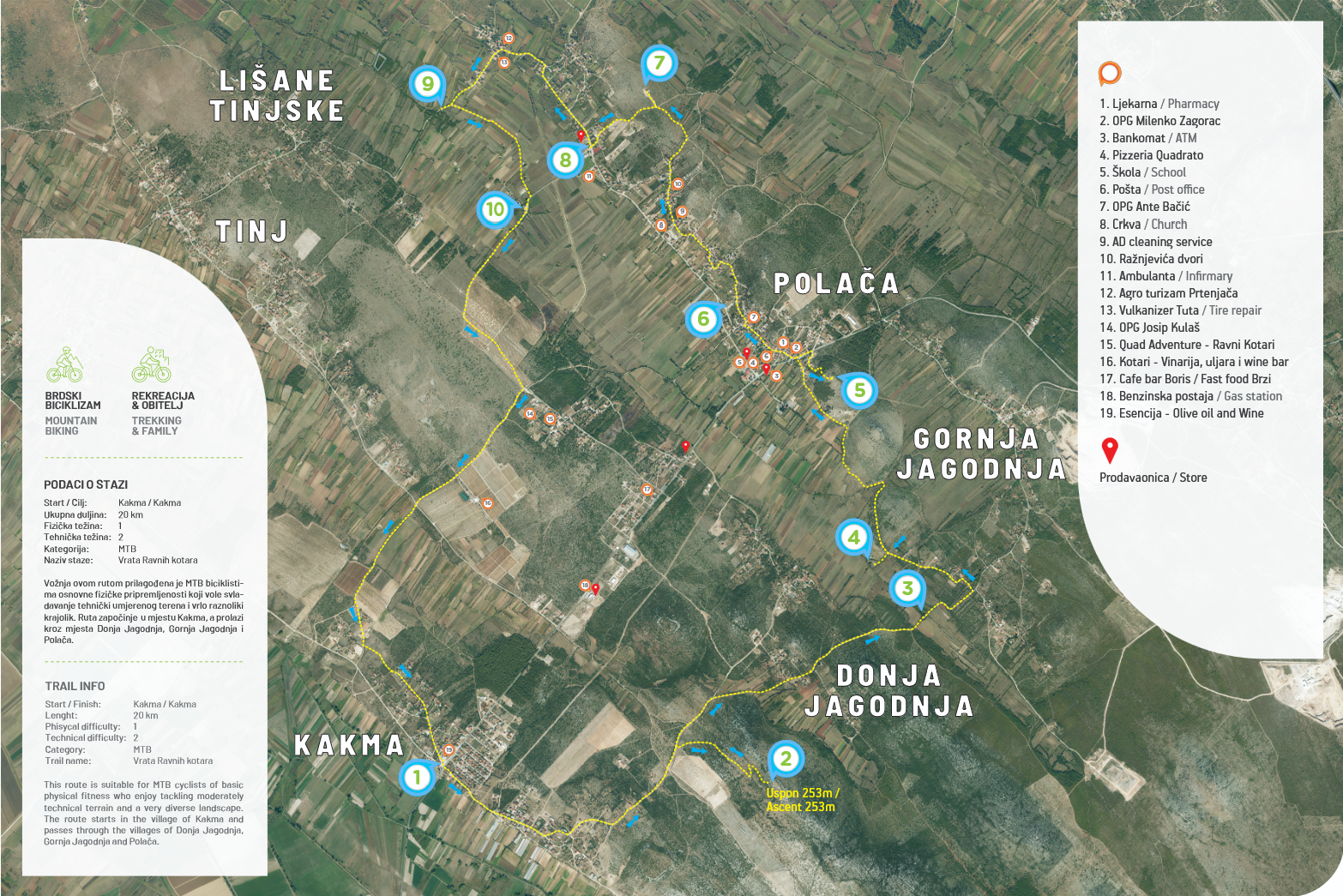
To view the route map, click the following link: View route map